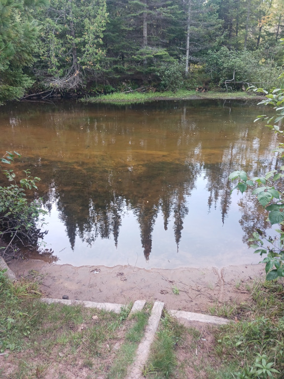
Here are some images of the Indian River where you can access it with your canoe or kayak.


You can read more about the Indian River Trail on this site’s trail page.
There are river trips where you spend half the day wondering when you’ll see the next person. The Indian River Canoe Trail in Michigan’s Upper Peninsula is one of those places.
Once your canoe or kayak is on the water, the noise of roads and towns fades pretty quickly. The river winds through the Hiawatha National Forest, passing through quiet stretches of northern hardwoods, pine, cedar, wetlands and connected lakes. You might see an eagle overhead, hear a loon before you see it, or spend ten minutes paddling along without seeing another boat.
And then there’s the occasional tree across the river just to keep things interesting.
The Indian River runs from the Fish Lake area toward Indian Lake, with numerous access points and camping opportunities along the way. The route is commonly described as roughly 36 to 41 miles, depending on which sections and connecting waters are included.
Where Is the Indian River Canoe Trail?
The Indian River Canoe Trail is located in the eastern Upper Peninsula within the Hiawatha National Forest. The Fish Lake access is approximately 36 miles northwest of Manistique and about 15 miles south of Munising.
The river eventually reaches Indian Lake, giving paddlers a long route through a remarkably quiet part of the U.P.
For someone coming from Manistique or Munising, this is a great trip to add to a weekend of camping, fishing and exploring.
Trail type: Canoe/Kayak
Region: Eastern Upper Peninsula
Forest: Hiawatha National Forest
Approximate route: 36–41 miles, depending on the section measured
River width: Approximately 30–50 feet in many sections
Typical depth: About 1–3 feet
Difficulty: Varies by water level and section
The river has a steady flow and is suitable for paddlers with different experience levels during normal conditions. Early-season water can be a completely different story.
What Is the Indian River Like?
Don’t expect a wide, open river where you can simply point your kayak downstream and put your paddle on autopilot.
The Indian River twists through the woods and wetlands, with sections that feel narrow and intimate. The surrounding forest includes northern hardwoods and mixed conifers, while marshy areas give the river a different character as you move along. The U.S. National Wild and Scenic Rivers System describes the river as changing from connected lakes in its upper reaches to a winding channel and later a braided channel surrounded by wetlands.
That variety is part of the fun.
One bend might have you paddling beneath a canopy of trees. A little farther along, the river opens up and gives you a better view of the sky. Then you’re back into the woods.
It’s the kind of trip where you stop checking the clock.
Fish Lake to Indian Lake
The Indian River Canoe Trail has numerous access points, making it possible to plan a short paddle rather than committing to the entire route.
Some of the listed access points include:
- Fish Lake Boat Launch
- Widewaters Campground
- Tommy Page Bridge
- McCormick Access
- Thunder Lake Road
- 8-Mile Bridge
- Palms Book State Park area
- Indian River Campground
Outdoor Michigan lists these access locations along the canoe trail and identifies both Fish Lake and Indian Lake as paddling and fishing waters.
That gives you some flexibility. A two-hour paddle can be a completely different outing from a two-day wilderness trip.
Indian River Canoe Trail Access Points
Fish Lake
Fish Lake is one of the primary starting points for the Indian River Canoe Trail. It’s a convenient place to put a canoe or kayak into the water before heading downstream.
If you’re planning a longer trip, this is where I’d start thinking about your shuttle plan before unloading the boat.
Nobody wants to finish 20 miles downstream and then realize the truck is sitting 20 miles in the other direction.
Widewaters Campground
Widewaters provides another access point and camping option along the route. It’s a handy choice for paddlers who want to turn the trip into an overnight adventure.
Tommy Page Bridge
The Tommy Page Bridge area provides a carry-in access point. It’s also near the Pine Marten Run Trail, giving hikers and paddlers another way to explore the area.
McCormick Access
McCormick is another carry-in access along the river and can be useful when planning a shorter section of the trail.
Thunder Lake Road
The Thunder Lake Road access provides another spot to reach the river without committing to the entire canoe trail.
8-Mile Bridge
The 8-Mile Bridge access is toward the lower portion of the route and is another carry-in launch listed for the Indian River Canoe Trail.
Wildlife Along the Indian River
Bring binoculars if you have room for them.
The Indian River provides habitat for bald eagles and ospreys, along with a variety of forest and wetland wildlife. The river also supports trout fishing and provides spawning habitat for lake sturgeon.
And don’t forget the little stuff.
Dragonflies skimming across the water. Frogs disappearing from the edge of the river. A kingfisher making that crazy rattling call before flying ahead of you.
Those are the moments that make a U.P. river trip memorable.
Fishing the Indian River
Fishing is another reason to bring a rod.
The river supports trout and other fish species, while the surrounding lakes add even more opportunities for anglers. The National Wild and Scenic Rivers System specifically identifies trout fishing as good along the river.
A canoe makes a pretty handy fishing platform, too.
Just don’t get so focused on the next good-looking pool that you forget to steer.
Ask me how I know.
When Is the Best Time to Paddle the Indian River?
Summer and early fall are popular choices for a relaxed canoe or kayak trip.
The river can be particularly enjoyable once the spring runoff has dropped and the current becomes more manageable. Upper Peninsula trail information recommends the period after mid-June for more typical paddling conditions.
Fall adds another reason to visit.
The hardwoods begin changing color, the bugs tend to become less annoying, and a cool morning on the river can be spectacular.
Just remember that weather in the U.P. can turn quickly. A sunny afternoon doesn’t guarantee a warm evening at your campsite.
How Long Does It Take to Paddle the Indian River?
That depends heavily on where you start and how often you stop.
A short section could make a good half-day outing. A longer trip can become a full-day paddle or an overnight adventure.
If you’re planning to cover much of the route, don’t calculate your trip based solely on the mileage. Current speed, water level, fallen trees, portages, fishing stops and lunch breaks all affect your travel time.
And if you’ve got a camera with you?
Forget your original estimate.
You’ll be stopping.
What to Bring
For a day trip, I’d have at least:
- Canoe or kayak
- Paddle and spare paddle if possible
- Personal flotation device
- Drinking water
- Food and snacks
- Dry bag
- Extra clothing
- Sunscreen
- Bug spray
- First-aid supplies
- Map or GPS
- Phone in a waterproof case
- Fishing gear if you’re planning to fish
For an overnight trip, add your camping equipment, food, water treatment supplies and everything needed to stay comfortable away from the road.
Don’t assume your phone will have a dependable signal.
A downloaded map is a much better friend than a loading circle.
Planning a Trip on the Indian River Canoe Trail
The biggest mistake would be treating this like a quick rental-canoe float.
Plan your entry and exit points first.
If you’re paddling a section of the Indian River, figure out:
- Where you’re putting in.
- Where you’re getting out.
- How you’re getting the vehicle to the other end.
- How long the section should take under current conditions.
- Where camping is allowed if you’re staying overnight.
- Whether water levels and recent river conditions make your planned section appropriate.
The Forest Service and local trail information are worth checking before leaving. Conditions can change when storms drop trees into the river, and a route that was easy last summer may have a surprise waiting around the bend this year.
Indian River Canoe Trail Map and Directions
The Indian River Canoe Trail is spread across a large portion of the Hiawatha National Forest, so having a map before you launch is a smart move.
The primary Fish Lake trailhead is approximately 36 miles northwest of Manistique and 15 miles south of Munising.
Several access points make it possible to build a trip around the amount of time you have rather than trying to paddle the entire route.
Those searches will help you find maps, access points and current information before you head out.
A Quiet U.P. Paddle Worth Putting on Your List
The Indian River isn’t the kind of Upper Peninsula attraction that needs a giant parking lot and a gift shop.
That’s part of why I like it.
You launch a canoe or kayak, start paddling and let the river set the pace. There are stretches where the woods seem to swallow up everything except the sound of your paddle hitting the water.
For someone looking for canoeing, kayaking, fishing, camping and quiet places to explore in Michigan’s Upper Peninsula, the Indian River Canoe Trail deserves a spot on the list.
Just check the water conditions, know your access points and don’t forget to look up from the paddle every once in a while.
You might miss the eagle.
Leave a Reply