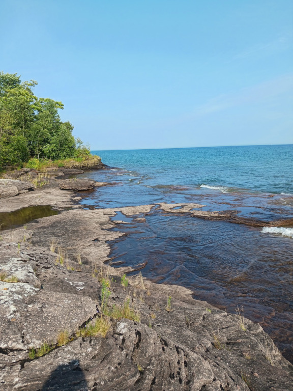
Point Abbaye is a rugged, remote peninsula in Michigan’s Upper Peninsula that juts out into Lake Superior, separating the Keweenaw Bay from the Huron Bay. As a scenic county park and protected natural area, it offers dramatic, panoramic views of the open lake, the Huron Islands, and the distant Keweenaw Peninsula. The landscape is defined by a dense, boreal forest of balsam fir and cedar that sharply gives way to striking, jagged shelves of Jacobsville sandstone along the water’s edge. Because it remains highly undeveloped and requires a long drive down a rough, unpaved two-track road, it is a pristine and solitary haven for bird watching, rock hunting, and catching spectacular sunrises and sunsets.
Camping at Point Abbaye is an entirely rustic, unplugged experience. If you want to spend the night under the stars at this remote tip of the Upper Peninsula, here is what you need to know about the layout and timing.
Camping Options & Facilities
- The Point Abbaye Campground: Located right at the rugged tip within the county park, this is a small, primitive campground meant for basic tent camping.
- The Amenities: Expect zero hookups. There is no electricity, running water, or trash service. The site features a couple of vault toilets/outhouses, fire rings, and picnic tables. You must pack out whatever you pack in and bring all of your own drinking water.
- Finlander Bay Natural Area: Located adjacent to the county park, the Keweenaw Land Trust manages this protected zone. They offer a vehicle access drive to a small camping area, but no motorized travel is permitted past that point to keep the shoreline pristine.
- Alternative Nearby State Parks: If you are traveling in a large camper or RV, the roads leading to the point are too rough and narrow. Instead, look into booking an electric or full-hookup site down the road at Baraga State Park or F.J. McLain State Park.
Best Time of Year to Visit
- Late Summer & Early Fall (August to October): This is the absolute prime window. By August and September, the infamous Upper Peninsula biting flies and mosquitoes have largely died down, and the weather is crisp and clear. Early autumn also brings stunning fall foliage against the deep blue backdrop of Lake Superior.
- Late Spring & Early Summer (May to July): Approach with caution. While beautiful, this is peak bug season. The stable flies, black flies, and mosquitoes can be intense enough to ruin a trip if you aren’t fully prepared. Furthermore, spring snowmelt turns the final miles of the dirt two-track road into a highly muddy, deeply rutted challenge.
- Winter: Inaccessible by standard vehicle. The county does not plow Point Abbaye Road all the way to the end. The final leg is strictly left to snowmobiles, snowshoers, or winter fat-tire bikers.
Address: 46°57’58” N, 88°08’38” W
Countie(s) trail is located in: Baraga
Trail Type(s): Hiking
Trail Measurement: Roughly 0.5 to 1 mile out and back
References and More Info
- Compass Latitude: 46°57’58” N
- Compass Longitude: 88°08’38” W
- Numeric Latitude: 46.966036° N
- Numeric Longitude: -88.144011° W
- Elevation in Feet: 610
- Elevation in Meters: 186
Leave a Reply