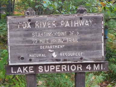
Address:
Countie(s) trail is located in: Alger
Trail Type(s): Camping <> Hiking <> Road Biking
Trail Measurement: 27.5 Miles
Trail Distance:
27.5 Miles
Directions:
Pathway Directions to Trailhead: Kingston Lake SF Campground (H-58 or Kingston Lake Rd); Seney Township Campground (5 miles N of Seney on Co Rd 450)
The Fox River Pathway is a remote, 27-31 mile point-to-point hiking trail in Michigan’s Upper Peninsula.
Trail Route and Basics
- Length: About 27 to 31 miles.
- Direction: Point-to-point trail.
- Endpoints: Runs from near Seney Township Park north to Kingston Lake State Forest Campground, close to Lake Superior.
- Camping: Passes rustic spots like the Fox River State Forest Campground.
The Hemingway Connection
- The River: The trail follows the Fox River. This river is a clear, natural stream known for wild brook trout.
- Famous Author: Famed author Ernest Hemingway fished this river. His trip inspired his famous short story, “Big Two-Hearted River”.
Trail Conditions
- Difficulty: Best for experienced hikers who know how to navigate with a map and compass.
- Maintenance: Parts of the trail are overgrown and have fallen trees. Other parts use sandy dirt roads.
- Challenges: Expect many mosquitoes during warm months, plus remote camping with few services.
Here are some images taken while visiting.


References and More Info
- UP Trails
- Compass Latitude: 46°23’59.5″N
- Compass Longitude: 86°01’50.5″W
- Numeric Latitude: 46.39985
- Numeric Longitude: -86.03069
- Elevation in Feet: 730 to 942
- Elevation in Meters: 223 to 287
- Trail Measurement: 27.5 Miles
Trailheads
1. Southern Trailhead (Seney, MI Entrance)
This endpoint is located just north of the town of Seney along the Fox River.
- Approximate Address: Fox River Road (County Road 450), Seney, MI 49883
- Digital Coordinates (Decimal Degrees):
46.39985, -86.03069 - Compass Coordinates (Degrees, Minutes, Seconds): 46°23’59.5″N, 86°01’50.5″W
2. Northern Trailhead (Kingston Lake Entrance)
This endpoint sits on the shores of Kingston Lake, just south of the Pictured Rocks National Lakeshore.
- Approximate Address: Kingston Lake State Forest Campground, H-58, Shingleton, MI 49884
- Digital Coordinates (Decimal Degrees):
46.60997, -86.22796 - Compass Coordinates (Degrees, Minutes, Seconds): 46°36’35.9″N, 86°13’40.7″W
Trail Overview & Access
If you are planning to navigate or through-hike the pathway, a prominent mid-trail access and parking zone can also be found at the Fox River State Forest Campground.
- Campground Location:
46.40025, -86.02848 - Compass Direction: The trail physically flows in a northwesterly direction from Seney up toward the headwaters and Kingston Lake
Leave a Reply